KMZ export
How to export your layout as a KMZ for review in Google Earth — the right deliverable for land teams and clients.
The KMZ export captures your finished layout — boundary, panel tables, ICR buildings, string inverters / SMBs, exclusion zones, and lightning arresters — in a single file your land team or client can open in Google Earth.
Most users send the KMZ alongside the PDF report: the PDF for the bid committee, the KMZ for anyone who wants to see the layout on satellite imagery.
Exporting the KMZ
Open the Download tab
Below the canvas, switch to the Download tab in the bottom panel. After a layout finishes, the KMZ row activates.
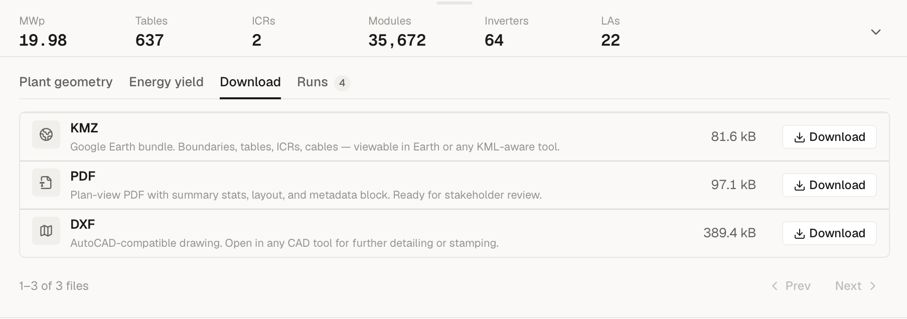
Pick a save location
The save dialog suggests <project>-<run>.kmz. Filesystem-illegal
characters in either name are mapped to -.
Wait
The KMZ is built by the cloud rollup pass alongside the PDF and DXF; saving it locally is a single presigned-URL fetch, usually under 5 seconds.
Share
Email or drop in your file-sharing channel. The recipient opens it in Google Earth Pro (free, desktop) or any KML-aware viewer.
What's in the exported KMZ
The KMZ contains one folder per plant, named after each plant's
boundary name (or Plant 1, Plant 2, … if your input KMZ didn't
name them). When the project has more than one plant, an additional
Overall Summary folder is added at the end.
Inside each plant folder, the structure is:
| Sub-folder / item | Contents |
|---|---|
| Boundary (polygon) | The plant boundary polygon, tinted in that plant's palette colour. |
| Plant name label (point) | A label-only placemark at the boundary centroid showing the plant name. |
| Exclusion Zones | One polygon per exclusion (water bodies, no-build zones, etc.). |
| MMS-Tables | One polygon per panel table, named R<row>-T<table>. The description shows row number, table number, module count, and table kWp. |
| ICR Buildings | One polygon per Inverter Control Room, named ICR-<index>, dimensions 40 m N-S × 14 m E-W. |
| Obstructions | User-drawn obstructions / internal roads, if any. |
| String Inverters or SMBs | One polygon per inverter or SMB (folder name depends on whether the design is string-inverter or central-inverter mode). Named INV-<index> or SMB-<index> with capacity and assigned table count. |
| Lightning Arresters | One polygon per LA, named LA-<index>, with footprint dimensions and protection radius in the description. Protection circles are not drawn in the KMZ (they're in the DXF). |
| <Plant name> — Details (point) | A summary placemark with an HTML table: area, design type, module spec, tilt, pitch, GCR, table count, capacity, ICR count, inverter topology, cable totals, energy yield (if calculated). |
DC and AC cable routes are intentionally excluded from the KMZ — they're carried in the DXF, and the cable totals are summarised in the per-plant details placemark. KMZ cable polylines tend to clutter Google Earth at zoom levels where land teams actually work; the totals + a per-plant summary read more cleanly.
The Overall Summary folder (multi-plant projects only) carries a single placemark with an HTML table aggregating per-plant area, table count, module count, capacity, pitch, and (when energy ran) year-1 yield, CUF, and 25-year total.
In Google Earth, the recipient can:
- Toggle individual folders on/off to focus on one layer.
- Click any placemark to see attributes (table ID, modules per table, kWp for a table, ICR dimensions, etc.).
- Switch between map, satellite, and terrain views.
What the KMZ is NOT
It's a visual review deliverable, not an engineering one. For engineering work — pile coordinates, electrical schematics, civil trench plans — use the DXF export into AutoCAD instead.
The KMZ doesn't include energy yield numbers in chart form either. The per-plant details placemark carries the headline figures (PR, specific yield, year-1 energy, CUF, 25-year total), but for the full energy walkthrough the PDF report is the right deliverable; the 15-minute CSV is what you'd hand to a financial modeller.
When to send the KMZ
The KMZ is the right export when:
- You're showing a land team what the layout will look like on their parcel.
- You're sending a client a layout preview before the bid package is final.
- You're doing a terrain / shading review in Google Earth.
- You want a lightweight artefact to drop in Slack / WhatsApp for quick discussion.